
Focus Areas
- Machine learning in the field of agriculture and vegetation
- Classification methods, such as supervised learning, unsupervised learning, self-taught learning
- Feature learning, representation learning
- Interpretability and explainability for deep neural networks
- Analysis techniques, such as clustering or archetypal analysis
- Pattern recognition in large data sets
Topic Propositions
Comparing Pre-Training Strategies for Sparsely Labeled Land Cover Classification
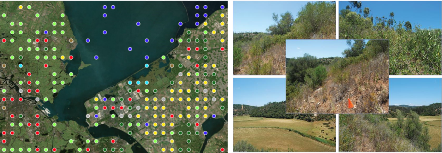
The use of survey data like Eurostat LUCAS for training land cover classification neural networks is an appealing alternative to the common practice of manual annotation. However, such data is sparse compared to satellite images’ spatial resolution, meaning that only a select few image pixels can be labeled. A popular way to improve the performance of neural networks in the face of data sparsity is pre-training. In this thesis, different pre-training strategies shall be compared by applying them to a dataset of Sentinel-2 and LUCAS data. In particular, we are interested in how pre-training on existing land cover datasets compares to domain-agnostic self-supervised techniques like image reconstruction or contrastive learning.
Supervision: Johannes Leonhardt, Ribana Roscher
Renaturation detection using esa Worldcover Maps of 2020 and 2021, and Sentinel-2 imagery (Bachelor Thesis)
German title: Detektion von Renaturierung unter Verwendung der ESA WorldCover karten von 2020 und 2021, und Sentinel-2 Bildern
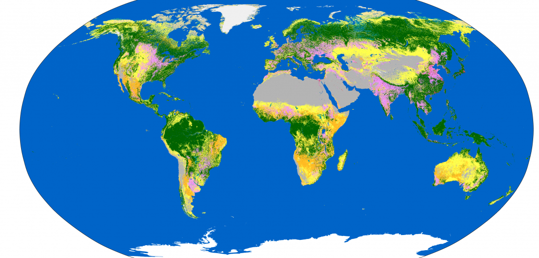
ESA WorldCover is a land cover dataset with 10 meters resolution which has been published for the years 2020 and 2021. Land cover changes within these two maps might reveal renaturation areas. However, since different algorithms have been used to generate the maps, differences might not only occur due to real land cover changes. Therefore, Sentinel-2 images must be used to validate the land cover changes in the ESA WorldCover maps.
Supervision: Ribana Roscher
Analyzing Sleep Patterns in Calves (Bachelor or Master thesis)
German title: Analyse des Schlafes bei Kälbern


Sleep is an important part of life, from human studies we know, that a lack of sleep can have a significant effect on health and welfare. It can be assumed that sleep also plays a role in farm animals – but scientific evidence is rare.
To analyze sleep a combination of different physiological parameters (electroencephalogram (EEG), electrooculogram (EOG) and electromyogram (EMG)) can be measured using mobile sleep labs. In the ‘Calf Sleep’ project, such polysomnographic data is recorded, furthermore we record the behavior of the animals in order to validate alternative methods for the measurement of sleep on farm.
Up to date, the data has to be analysed manually, which is both, time consuming and prone to errors. The aim of two master thesis is to develop algorithms to automate and thus significantly simplify the analysis of this data:
- Development of machine learning algorithms to analyze different body positions of calves.
- Development of a pattern recognition algorithms to analyze different sleep stages from polysomnographic data.
Supervision: Ribana Roscher, ITW Bonn
Detection Of Iceberg Rafted Debris in X-Ray Cores
German title: Detektion von Eisberg-Geröllen in Röntgenaufnahmen von Bohrkernen
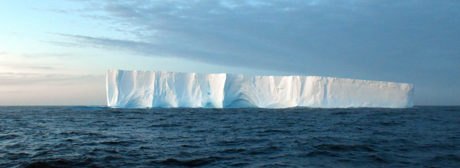
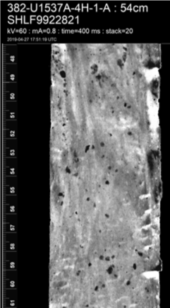
Analyzing the current and past behavior of the Antarctic ice sheet is a major research area to get information about the long-term climate history of Antarctica and to predict the future behavior of the ice sheet. As soon as wandering icebergs reach warmer waters, the debris they carry (so-called iceberg rafted debris) falls down through the ocean as consequence of the melting process. The debris is deposited as sediment on the seafloor and gives, when analyzed, valuable information about changes in the ice sheet.
This thesis is concerned with an automatic algorithm to detect debris in x-ray images of drill cores, which were collected during an Antarctica expedition in 2019. Supervised learning with convolutional neural networks will be utilized to detect debris and estimate position and size in the drill core. The algorithm will be analyzed by manual annotations provided by experts.
Supervision: Ribana Roscher, Mike Weber (Institute for Geosciences Department of Geochemistry and Petrology)
Erfassung landwirtschaftlicher Praktiken in Deutschland – Analyse von Bodenbearbeitung und Glyphosateinsatz im deutschen Ackerbau (Master Thesis)
Die Art und Weise, wie wir unsere Nahrungsmittel herstellen, ist unumstritten ein wichtiger
Einflussfaktor für das Erreichen globaler und lokaler Umweltziele. Um jedoch entsprechende agrarpolitische Maßnahmen effizient und zielführend auszugestalten, ist detailliertes Wissen über die Verbreitung und Nutzung verschiedener landwirtschaftlicher Praktiken fundamental – das Sammeln und Aufbereiten eben solcher Informationen stellt Forschende und Entscheidungsträger*innen jedoch bisher oft vor viele Probleme, da Daten nur eingeschränkt verfügbar und/oder schwer zu erheben sind.
Das TrAgS-Projekt (Tracking the use and adoption of Agricultural technologies through Satellite remote sensing and self-supervised deep learning) adressiert diese Schwierigkeit der Datenverfügbarkeit und hat das Ziel, die Analyse von Landwirtschaftstechnologien mithilfe von Satellitenfernerkundungsdaten und maschinellem Lernen zu verbessern.
Die Masterarbeit sollte umfassen:
- Das Ausformulieren der Umfrage und Verteilen dieser unter deutschen Ackerbau-Landwirten
- Unterstützung in der Koordination für die technische Umsetzung der Befragung
- Das Ordnen und Filtern der erhobenen Daten
- Deskriptive Auswertung der Daten hinsichtlich des Nutzens besagter Praktiken
- Eine erste Analyse und Interpretation der gefundenen Nutzungsmuster
Bitte beachten: Diese Arbeit wird nicht von unserer Gruppe betreut. Wir sind jedoch involviert, da die Ergebnisse der Arbeit für unsere Arbeit im TrAgS Projekt relevant.
Supervision: Alexa Leyens, Hugo Storm
Exploring the Sensitivity of Model Uncertainty to Hyperparameter Variations: A Systematic Analysis
Imagine this: you’ve trained a deep learning model that predicts traffic patterns. It seems perfect on the test set—accurate, efficient, and ready to deploy. But can you trust it to handle rare, unpredictable scenarios, like a sudden traffic jam caused by an accident?
This is where uncertainty estimation steps in, acting like a reliability score for machine learning models. In critical applications like healthcare, autonomous driving, and financial forecasting, knowing not just what a model predicts but how certain it is can make all the difference between success and failure.
But here’s the twist: the reliability of uncertainty estimation isn’t set in stone. It’s shaped by our choices we make during model training—like how fast we let the model learn (learning rate) or how often we drop connections (dropout rate).
This study explores a simple but profound question: How do these hyperparameters influence model uncertainty? By uncovering the hidden relationships between hyperparameters and uncertainty metrics, this thesis aims to guide practitioners toward building models that are not only accurate but also confident.
More details:
Supervision: Mohamed Farag , Ribana Roscher
The Effect of Architecture Selection on Prediction Uncertainty
Imagine designing a rocket. The materials and structure you choose will determine not just how high it can fly but also how reliably it can withstand turbulence. In machine learning, architectures are the blueprints, shaping not only what a model predicts but also how confident it is in those predictions.
As machine learning expands into critical domains like autonomous driving and medical diagnostics, prediction uncertainty has emerged as a measure of reliability. But how does the choice of architecture—from traditional CNNs to cutting-edge Vision Transformers—affect prediction uncertainty? This study investigates the relationship between architecture and uncertainty, aiming to provide practitioners with the insights they need to pick the right one for the downstream task.
More details:
Supervision: Mohamed Farag, Ribana Roscher