A BENCHMARK FOR LEARNING WITH ARTIFICIAL OBJECTS
FOR IMPROVED AERIAL VEHICLE DETECTION


In order to enable the development of powerful machine learning methods for remote sensing-based Earth observation tasks, benchmarks are needed to comprehensively evaluate the methods and compare them to other methods. We present ArtifiVe-Potsdam (Artificial Vehicles), a freely available dataset targeting vehicle detection in aerial imagery. In particular, the benchmark focuses on enriching real datasets with artificial data and quantifying the added value. The dataset aims to stimulate research on the efficient and cost-effective creation and enrichment of datasets for remote sensing, where datasets with a limited number of labels are common and the collection of data and labels is time-consuming and expensive.
What do we provide?
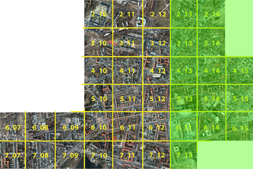
- a real dataset showing the City of Potsdam that is based on the ISPRS 2D Semantic Labeling Contest
- Potsdam fullsized: 6000 × 6000 px
- Potsdam patched: 600 × 600 px
- Potsdam patched + overlap: 600 × 600 px + 200 px
- an artificial dataset containing synthetic backgrounds and vehicles
- artificial: 600 × 600 px
- vehicle annotations in form of WKT polygons
- code to read images and annotations
Dataset sizes
| dataset | training images | test images |
| Potsdam fullsized | 24 | 14 |
| Potsdam patched | 2400 | 1400 |
| Potsdam patched + overlap | 5400 | 3150 |
| artificial | 1000 |
If you are using the data please cite the following work
- I. Weber, J. Bongartz, and R. Roscher, “Artifive-potsdam: a benchmark for learning with artificial objects for improved aerial vehicle detection,” in Proc. of the ieee international geoscience and remote sensing symposium (IGARSS), 2021.
[Bibtex]@InProceedings{weber2021artifive, author = {Weber, Immanuel and Bongartz, Jens and Roscher, Ribana}, title = {ArtifiVe-Potsdam: A Benchmark for Learning with Artificial Objects for improved aerial Vehicle Detection}, booktitle = {Proc. of the IEEE International Geoscience and Remote Sensing Symposium ({IGARSS})}, year = {2021}, }
People


Credits
We thank the creators of the ISPRS 2D Semantic Labeling Contest for the permission to use their imagery as the excellent base of our dataset.
We also thank drawingdatabase.com for the permission to use their data as the base for the artificial vehicles.
Copyright
The datasets provided on this page are published under the Creative Commons Attribution-NonCommercial-ShareAlike 3.0 License. This means that you must attribute the work in the manner specified by the authors, you may not use this work for commercial purposes and if you alter, transform, or build upon this work, you may distribute the resulting work only under the same license. If you are interested in commercial usage you can contact us for further options.